File:Delhi Aerial View, Satellite Image, India September 2003.jpg

原始文件 (2,319 × 2,037像素,文件大小:1.43 MB,MIME类型:image/jpeg


摘要

描述
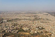
English: The capital of India, New Delhi is a city within a city -- part of the Delhi metropolitan area, which occupies nearly 1,500 square kilometers (537 square miles) and is home to nearly 22 million people. New Delhi was established in the early 1900s as the capital of the British Empire in India, and it became the Indian national capital after the country gained independence in 1947. The city is simply Delhi's newest incarnation; cities have been located at the site for thousands of years.

This image of New Delhi was captured by the Advanced Spaceborne Thermal Emission and Reflection Radiometer asterweb.jpl.nasa.gov (ASTER) on NASA's terra.nasa.gov Terra satellite on September 22, 2003. The city has undergone lots of changes between 2003 and 2013.

The dramatic differences in the landscapes tell some of the city's history. When the British moved the capital of their empire from Calcutta to Delhi, they built New Delhi on the west bank of the Yamuna River, south of the Old City. The Old City, which had been the last capital of the Mughal Empire, had densely packed, low-rise buildings, crowded along narrow, irregular streets. Little vegetation interrupted the urban expanse. In contrast, the buildings of New Delhi were laid out along wide, tree-lined avenues that connected monuments, parks, and government buildings. Among the most obvious of these avenues is the Rajpath, visible as a green strip across the heart of New Delhi. The Rajpath connects the grounds of the President's estate on the west to the India Gate (a World War I memorial) on the east.

To the west of New Delhi is the Central Ridge Forest Reserve, which gives a hint of how the landscape would have looked before human development. The vegetation is a mixture of thorn scrub and woodlands. Ecologists debate how abundant the thorn scrub would actually have been in the pre-settlement landscape. It may be the result of degradation of the tropical dry forests through grazing and other agricultural activity over centuries. Northwest of the urban forest is a patchwork of fertile and fallow fields that are part of the campus of the Indian Agricultural Research Institute.

ASTER image courtesy of NASA/GSFC/METI/ERSDAC/JAROS, and the U.S./Japan asterweb.jpl.nasa.gov/ ASTER Science Team. Caption by Rebecca Lindsey.
日期
来源 http://earthobservatory.nasa.gov/IOTD/view.php?id=8463
作者 NASA
其他版本

许可协议

Public domain 本文件完全由NASA创作,在美国属于公有领域。根据NASA的版权方针,NASA的材料除非另有声明否则不受版权保护。(参见Template:PD-USGov/zhNASA版权方针页面JPL图片使用方针。)
警告:
註解
InfoField
該圖片含有註解:在維基媒體共享資源上查看註解

说明

添加一行文字以描述该文件所表现的内容

此文件中描述的项目

描繪內容

image/jpeg

文件历史

点击某个日期/时间查看对应时刻的文件。

日期/时间缩⁠略⁠图大小用户备注
当前2013年12月16日 (一) 21:542013年12月16日 (一) 21:54版本的缩略图2,319 × 2,037(1.43 MB)M Tracy HunterUser created page with UploadWizard

以下页面使用本文件:

全域文件用途

以下其他wiki使用此文件: