File:HICKORY TOWN HALL AND POLLING PLACE - NARA - 552509.jpg

本预览的尺寸:800 × 539像素。 其他分辨率:320 × 216像素 | 640 × 432像素 | 1,024 × 691像素 | 1,280 × 863像素 | 3,000 × 2,023像素。
原始文件 (3,000 × 2,023像素,文件大小:753 KB,MIME类型:image/jpeg)
摘要
| HICKORY TOWN HALL AND POLLING PLACE
( |
|||||||||||||||||||||||||||
|---|---|---|---|---|---|---|---|---|---|---|---|---|---|---|---|---|---|---|---|---|---|---|---|---|---|---|---|
| 作者 |
Greenberg, Arthur, Photographer (NARA record: 8464446) |
||||||||||||||||||||||||||
| Record creator | Environmental Protection Agency. (12/02/1970 - ) | ||||||||||||||||||||||||||
| 标题 |
HICKORY TOWN HALL AND POLLING PLACE |
||||||||||||||||||||||||||
| 描述 |
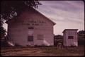
English: Hickory Township hall, Sheldons Grove, Illinois; the main building, at 40°9′58.4″N 90°17′38.3″W / 40.166222°N 90.293972°W, still exists next to the current township hall as of 2016. |
||||||||||||||||||||||||||
| 描绘地点 |
Springfield (Sangamon, Illinois, United States, North and Central America) inhabited place (39°48′00″N 89°37′59″W / 39.8°N 89.633°W; NARA geographical record) |
||||||||||||||||||||||||||
| 日期 | 1973年6月 | ||||||||||||||||||||||||||
| 館藏 |
|
||||||||||||||||||||||||||
| Record ID |
NAIL Control Number: NWDNS-412-DA-10024
|
||||||||||||||||||||||||||
| 来源 | U.S. National Archives and Records Administration | ||||||||||||||||||||||||||
| 其他版本 |
请不要覆盖此文件:任何裁剪或其他修复工作应以新文件名上传,并在此页使用“other versions=”参数标注,故该文件能够保持其所链接的NARA原样。此页面上的元数据直接导入自NARA档案记录;维基用户可以添加辅助描述文本至“description=”参数下,但请不要修改其他内容。
|
||||||||||||||||||||||||||


| 物体位置 | | 在以下服务上查看本图像和附近其他图像: OpenStreetMap |
|---|
许可协议
这个文件是由国家档案和记录管理局作为一项合作计划提供给维基共享资源的。国家档案和记录管理局提供公有领域或自由授权的展示美国人以及全球历史的图片。
|
|
|
||
文件历史
点击某个日期/时间查看对应时刻的文件。
| 日期/时间 | 缩略图 | 大小 | 用户 | 备注 | |
|---|---|---|---|---|---|
| 当前 | 2011年10月29日 (六) 07:52 | | 3,000 × 2,023(753 KB) | US National Archives bot | == {{int:filedesc}} == {{NARA-image-full | Title = HICKORY TOWN HALL AND POLLING PLACE | Scope and content = | General notes = | ARC = 552509 | Local identifier = 412-DA-10024 | Creator |
文件用途
以下页面使用本文件:
全域文件用途
以下其他wiki使用此文件:
- en.wikipedia.org上的用途
- www.wikidata.org上的用途