File:Saint-Félix-Lauragais - La Halle.jpg

原始文件 (7,360 × 4,204像素,文件大小:18.87 MB,MIME类型:image/jpeg


摘要

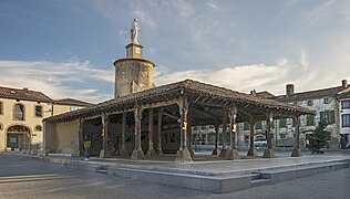
Saint-Félix-Lauragais Haute-Garonne, France - The covered market, fifteenth century

VI seal

根据最有价值图像标准,这张图像被评定为在Saint-Félix-Lauragais, Haute-Garonne, France. The covered market - Northwest exposure范畴内最有价值的共享资源图像。你可以在Commons:Valued image candidates/Saint-Félix-Lauragais - La Halle.jpg参看它的提名。

描述
English: Saint-Félix-Lauragais. The covered market Town Hall Square, fifteenth century. it consists of sixteen octagonal wooden pillars with stone keys. Bases and capitals are molded, and support the quarries and farms of the roof. A tower is adjoining the hall on Southeast side.
Français : Saint-Félix-Lauragais. La halle place de la mairie. Ouvrage du XVe siècle. elle se compose de seize piliers octogonaux en bois portant des clés de pierre. Bases et chapiteaux sont moulurés, et supportent les sablières et les fermes de la toiture. Une tour est adossée à la halle sur côté Sud-est.
This building is classé au titre des monuments historiques de la France. It is indexed in the base Mérimée, a database of architectural heritage maintained by the French Ministry of Culture, under the reference PA00094456 .

brezhoneg  català  Deutsch  English  español  Esperanto  euskara  français  italiano  magyar  Nederlands  português do Brasil  português  română  sicilianu  slovenščina  suomi  svenska  Ελληνικά  беларуская (тарашкевіца)  македонски  русский  українська  বাংলা  +/−
日期 摄于2015年12月27日
来源 自己的作品
作者 Didier Descouens
授权
(二次使用本文件)
This file is copyrighted and has been released under a license which is incompatible with Facebook's licensing terms. It is not permitted to upload this file at Facebook.
我,本作品著作权人,特此采用以下许可协议发表本作品:
w:zh:知识共享
署名 相同方式共享
本文件采用知识共享署名-相同方式共享 4.0 国际许可协议授权。
您可以自由地:
  • 共享 – 复制、发行并传播本作品
  • 修改 – 改编作品
惟须遵守下列条件:
  • 署名 – 您必须对作品进行署名,提供授权条款的链接,并说明是否对原始内容进行了更改。您可以用任何合理的方式来署名,但不得以任何方式表明许可人认可您或您的使用。
  • 相同方式共享 – 如果您再混合、转换或者基于本作品进行创作,您必须以与原先许可协议相同或相兼容的许可协议分发您贡献的作品。
其他版本
物体位置43° 26′ 56.7″ 北, 1° 53′ 15.97″ 东 Kartographer map based on OpenStreetMap.在以下服务上查看本图像和附近其他图像: OpenStreetMapinfo

说明

添加一行文字以描述该文件所表现的内容

此文件中描述的项目

描繪內容

共享资源质量评价 简体中文(已转写)

摄影器材 简体中文(已转写)

43°26'56.695"N, 1°53'15.972"E

曝光时间 简体中文(已转写)

0.005

28 毫米

image/jpeg

19,785,730 字节

4,204 像素

7,360 像素

ace77aea0a932bf6191b861fa24258874081831a

文件历史

点击某个日期/时间查看对应时刻的文件。

日期/时间缩⁠略⁠图大小用户备注
当前2016年1月4日 (一) 07:332016年1月4日 (一) 07:33版本的缩略图7,360 × 4,204(18.87 MB)Archaeodontosaurus{{Information |Description ={{en|1=c}} |Source ={{own}} |Author =Archaeodontosaurus |Date = |Permission = |other_versions = }}

以下页面使用本文件:

全域文件用途

以下其他wiki使用此文件:

元数据