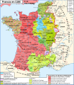
File:Map France 1180-fr.svg

此 SVG 檔案的 PNG 預覽的大小:527 × 600 像素。 其他解析度:211 × 240 像素 | 422 × 480 像素 | 675 × 768 像素 | 900 × 1,024 像素 | 1,800 × 2,048 像素 | 988 × 1,124 像素。
原始檔案 (SVG 檔案,表面大小:988 × 1,124 像素,檔案大小:1.88 MB)
檔案歷史
點選日期/時間以檢視該時間的檔案版本。
| 日期/時間 | 縮圖 | 尺寸 | 使用者 | 備註 | |
|---|---|---|---|---|---|
| 目前 | 2009年1月9日 (五) 11:35 |  | 988 × 1,124(1.88 MB) | ZigeunerAlt | + seigneurie de Montpensier, couleur du Velay, vicomté de Marsan |
| 2008年12月12日 (五) 15:51 |  | 988 × 1,124(1.88 MB) | ZigeunerAlt | Retour des limites d'arrière-fiefs dans le duché d'Aquitaine | |
| 2008年12月12日 (五) 14:07 |  | 988 × 1,124(1.88 MB) | ZigeunerAlt | + comté d'Alençon, seigneurie d'Harcourt (Normandie) | |
| 2008年12月6日 (六) 15:42 |  | 988 × 1,124(1.88 MB) | ZigeunerAlt | Tonnerre de la même couleur que Nevers et Auxerre | |
| 2008年12月5日 (五) 22:43 |  | 988 × 1,124(1.88 MB) | ZigeunerAlt | Couleurs identiques pour Flandres/Vermandois/Valois | |
| 2008年12月3日 (三) 15:02 |  | 988 × 1,124(1.88 MB) | ZigeunerAlt | {{Information |Description={{en|1=Map of the France in 1180}} {{fr|1=Carte de la France en 1180}} |Source=travail personnel (own work) |Author=Zigeuner |Date=3 XII 2008 |Permission= |other_versions=Image:Map France 1030-fr.svg }} <!--{{ |
檔案用途
下列2個頁面有用到此檔案:
全域檔案使用狀況
以下其他 wiki 使用了這個檔案:
- avk.wikipedia.org 的使用狀況
- bg.wikipedia.org 的使用狀況
- bn.wikibooks.org 的使用狀況
- cs.wikipedia.org 的使用狀況
- da.wikipedia.org 的使用狀況
- de.wikipedia.org 的使用狀況
- el.wikipedia.org 的使用狀況
- en.wikipedia.org 的使用狀況
- en.wikibooks.org 的使用狀況
- eo.wikipedia.org 的使用狀況
- es.wikipedia.org 的使用狀況
- et.wikipedia.org 的使用狀況
- eu.wikipedia.org 的使用狀況
- fi.wikipedia.org 的使用狀況
- fr.wikipedia.org 的使用狀況
檢視此檔案的更多全域使用狀況。


