File:DESERTEC-Map large.jpg

原始檔案 (5,776 × 4,184 像素,檔案大小:8.61 MB,MIME 類型:image/jpeg


本圖片是以PNG、GIF或JPEG格式上傳。然而,其中包含的資料或訊息,應該重新建立成可縮放向量圖形SVG)檔案,以更有效率或更準確的方式儲存。如有可能,請上傳本圖片的SVG格式版本。在上傳之後,請修改維基各姊妹計畫中所有使用舊版圖片的條目(列在圖像連結章節中),替換為新版圖片,並在舊圖片的描述頁中加入{{Vector version available|新圖片名稱.svg}}模板,同時移除本模板。
描述
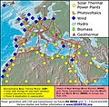
English: DESERTEC EU-MENA Map: Sketch of possible infrastructure for a sustainable supply of power to Europe, the Middle East and North Africa (EU-MENA) proposed by TREC)

For illustration: The red squares represent the total surfaces needed for solar collectors of Concentrating Solar Thermal Power (CSP) plants to provide the present electricity demands

- for the world (18.000 TWh/a, 300x300 km)

- for Europe (EU 3.200 TWh/a, 125x125 km)

- and for Germany or MENA (Middle East and North Africa, about 600 TWh/a, 55x55 km).

- The square labeled "TRANS-CSP Mix EUMENA 2050" indicates the surface needed for solar collectors to realize DESERTEC in EU-MENA (according to the TRANS-CSP scenario by DLR). This way the needs for seawater desalination and about two-thirds of the rising electricity consumption in the MENA region could be provided and about 17 percent of the European electricity consumption in 2050 (2,940 TWh/a, 120x120 km² in total).

In reality numerous CSP-Plants will be spread in the deserts of EU-MENA and around the globe.


Deutsch: DESERTEC EU-MENA Karte: Skizze einer möglichen Infrastruktur für eine nachhaltige Stromversorgung in Europa, dem Nahen Osten und Nord-Afrika (EU-MENA).

Zur Veranschaulichung: Die durch die roten Quadrate markierten Flächen für Solarkollektoren würden genügen, um in solarthermischen Kraftwerken (CSP) den Strombedarf

- der Welt (18.000 TWh/a, 300x300 km),

- Europas (EU, 3.200 TWh/a, 125x125 km)

- und von Deutschland bzw. MENA (Middle East and North Africa, ca. 600 TWh/a, 55x55 km) zu erzeugen.

- Das Quadrat "TRANS-CSP Mix EUMENA 2050" zeigt die insgesamt benötigte Fläche für Solarkollektoren, um DESERTEC in EU-MENA zu realisieren (entsprechend dem TRANS-CSP Szenario des DLR). Auf diese Weise könnte genügend Energie erzeugt werden, um den Bedarf an Meerwasserentsalzung und zwei Drittel des bis 2050 stark wachsenden Strombedarfs der MENA-Region zu decken sowie etwa 17 Prozent des europäischen Strombedarfs (zusammen 2,940 TWh/a, 120x120 km).

In der Realität werden viele CSP-Kraftwerke über die Wüsten der MENA-Region und der Welt verteilt sein. Die gestrichelten Linien stellen eine zweite Ausbaustufe dar.
日期
來源 http://www.desertec.org/fileadmin/downloads/press/DESERTEC-Map.zip
作者 DESERTEC Foundation, www.desertec.org
授權許可
(重用此檔案)
w:zh:共享創意
姓名標示 相同方式分享
您可以自由:
  • 分享 – 複製、發佈和傳播本作品
  • 重新修改 – 創作演繹作品
惟需遵照下列條件:
  • 姓名標示 – 您必須指名出正確的製作者,和提供授權條款的連結,以及表示是否有對內容上做出變更。您可以用任何合理的方式來行動,但不得以任何方式表明授權條款是對您許可或是由您所使用。
  • 相同方式分享 – 若要根據本素材進行再混合、轉換或創作,則必須以與原作相同或相容的授權來發布您的作品。
according to Desertec Press, and as written:
"Use of Contents
The whole contents of this website are licensed under the Creative Commons Attribution ShareAlike 2.5 License.
You are permitted (and welcome) to use any of the contents of this website but please acknowledge the source of any such information." (check on webarchive snapshot)
其他版本

說明

添加單行說明來描述出檔案所代表的內容

在此檔案描寫的項目

描繪內容

著作權狀態 繁體中文 (已轉換拼寫)

有著作權 繁體中文 (已轉換拼寫)

多媒體型式 繁體中文 (已轉換拼寫)

image/jpeg

校驗和 繁體中文 (已轉換拼寫)

ac4b286240d4b1873eed028323eafdedfd83a2f8

斷定方法:​SHA-1 中文 (已轉換拼寫)

9,032,929 位元組

4,184 像素

5,776 像素

檔案歷史

點選日期/時間以檢視該時間的檔案版本。

日期/時間縮⁠圖尺寸用戶備⁠註
目前2011年2月7日 (一) 19:40於 2011年2月7日 (一) 19:40 版本的縮圖5,776 × 4,184(8.61 MB)Benderson2~commonswikiUdated version http://www.desertec.org/en/press/ without symols in the Western Sahara conflict region.
2009年3月5日 (四) 17:39於 2009年3月5日 (四) 17:39 版本的縮圖5,777 × 4,185(8.09 MB)Chstdu{{Information |Description={{en|1=Sketch of possible infrastructure for a sustainable supply of power to EUrope, the Middle East and North Africa (EU-MENA) (Euro-Supergrid with a EU-MENA-Connection proposed by [[w:Trans-Mediterranean_Renewable_Energy_Coop

下列頁面有用到此檔案:

全域檔案使用狀況

以下其他 wiki 使用了這個檔案:

詮釋資料