File:Titan globe.jpg

預覽大小:600 × 600 像素。 其他解析度:240 × 240 像素 | 480 × 480 像素 | 768 × 768 像素 | 1,024 × 1,024 像素 | 2,048 × 2,048 像素 | 2,575 × 2,575 像素。
原始檔案 (2,575 × 2,575 像素,檔案大小:1.65 MB,MIME 類型:image/jpeg)
|
摘要
| 描述 |
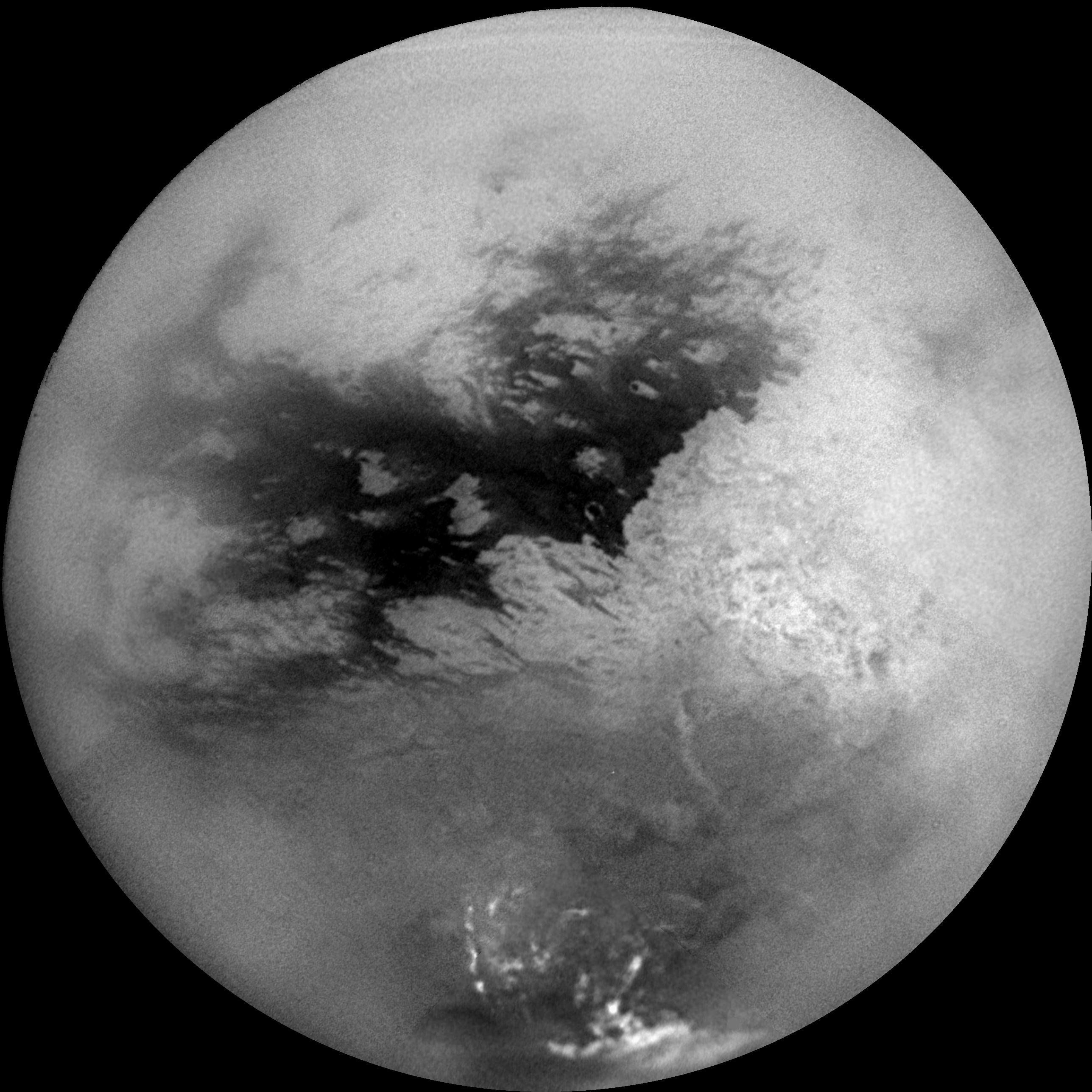
English: A mosaic of nine processed images acquired during Cassini's first very close flyby of Saturn's moon Titan on Oct. 26, 2004, constitutes the most detailed full-disc view of the mysterious moon. The view is centered on 15 degrees South latitude, and 156 degrees West longitude. Brightness variations across the surface and bright clouds near the south pole are easily seen. The images that comprise the mosaic have been processed to reduce the effects of the atmosphere and to sharpen surface features. The mosaic has been trimmed to show only the illuminated surface and not the atmosphere above the edge of the moon. The Sun was behind Cassini so nearly the full disc is illuminated. Pixels scales of the composite images vary from 2 to 4 kilometers per pixel (1.2 to 2.5 miles per pixel). Surface features are best seen near the center of the disc, where the spacecraft is looking directly downwards; the contrast becomes progressively lower and surface features become fuzzier towards the outside, where the spacecraft is peering through haze, a circumstance that washes out surface features. The brighter region on the right side and equatorial region is named Xanadu Regio. Scientists are actively debating what processes may have created the bizarre surface brightness patterns seen here. The images hint at a young surface with no obvious craters. However, the exact nature of that activity, whether tectonic, wind-blown, fluvial, marine, or volcanic is still to be determined. The images comprising this mosaic were acquired from distances ranging from 650,000 kilometers (400,000 miles) to 300,000 kilometers (200,000 miles).
Français : Titan : une des lunes de Saturne vue par la mission Cassini, le 26 octobre 2004. Cette mosaïque de neuf images montre des variations d'éclat de la surface de Titan, et des nuages lumineux près du pôle sud. Elle est centrée sur 15° Sud, 156° Ouest. Les images ont été traitées afin d'améliorer la netteté des détails de la surface. Malgré cela, plus on s'approche du limbe, plus l'image est floue car la ligne de visée traverse davantage d'atmosphère. La région la plus lumineuse du côté droit et la région équatoriale portent le nom de Xanadu Regio. La surface semble jeune et il n'y a pas de cratère visible. Les images ont été prises d'une distance variant entre 650 000 et 300 000 km.
Deutsch: Mosaik von Aufnahmen der Oberfläche Titans während des ersten Vorbeifluges von Cassini am 26. Oktober 2004.
Italiano: Mosaico composto da nove immagini scattate durante il primo sorvolo ravvicinato di Titano, una luna di Saturno, il 26 ottobre 2004. Costituisce la visuale più dettagliata dell'intera superficie della misteriosa luna. |
| 日期 | 2004年10月26日 (image taken on that day) |
| 來源 |
NASA planetary photojournal |
| 作者 | NASA/JPL/Space Science Institute |
| 授權許可 (重用此檔案) |
Copyright information from http://www.jpl.nasa.gov/images/policy/index.cfm - Unless otherwise noted, images and video on JPL public web sites (public sites ending with a jpl.nasa.gov address) may be used for any purpose without prior permission [...] |
授權條款
| 本作品由NASA創作,屬於公有領域。根據NASA的版權政策:“NASA的創作除非另有聲明否則不受版權保護。”(參見:Template:PD-USGov/zh,NASA版權政策或JPL圖像使用政策) | ||
 |
警告:
|
檔案歷史
點選日期/時間以檢視該時間的檔案版本。
| 日期/時間 | 縮圖 | 尺寸 | 使用者 | 備註 | |
|---|---|---|---|---|---|
| 目前 | 2018年12月12日 (三) 14:17 | | 2,575 × 2,575(1.65 MB) | Kesäperuna | 100% JPEG quality from full quality TIFF. |
| 2009年1月8日 (四) 12:24 |  | 2,575 × 2,575(525 KB) | OhanaUnited | Reverted to version as of 15:59, 8 April 2005 (was vandalized) | |
| 2008年11月13日 (四) 10:36 |  | 1,000 × 1,000(100 KB) | Ytsk | Reverted to version as of 01:07, 17 January 2005 | |
| 2005年4月8日 (五) 15:59 |  | 2,575 × 2,575(525 KB) | Arnomane | higher resolution | |
| 2005年1月17日 (一) 01:07 |  | 1,000 × 1,000(100 KB) | Kristaga | From en.wiki (ESA image) |
檔案用途
下列5個頁面有用到此檔案:
全域檔案使用狀況
以下其他 wiki 使用了這個檔案:
- af.wikipedia.org 的使用狀況
- als.wikipedia.org 的使用狀況
- ar.wikipedia.org 的使用狀況
- be.wikipedia.org 的使用狀況
- bg.wikipedia.org 的使用狀況
- bs.wikipedia.org 的使用狀況
- ca.wikipedia.org 的使用狀況
- de.wikipedia.org 的使用狀況
- en.wikipedia.org 的使用狀況
- Xanadu (Titan)
- Shangri-La (Titan)
- Wikipedia:WikiProject Astronomy/Recognized content
- Portal:Solar System
- Portal:Solar System/Selected picture
- Wikipedia:Featured pictures thumbs/12
- Wikipedia:Featured picture candidates/July-2008
- Wikipedia:Featured picture candidates/Titan globe
- Wikipedia:Wikipedia Signpost/2008-07-14/Features and admins
- Wikipedia:Wikipedia Signpost/2008-07-14/SPV
- User talk:OhanaUnited/Archive 12
- Wikipedia:Featured pictures/Space/Looking out
- Wikipedia:Featured picture candidates/delist/2009
- Wikipedia:Picture of the day/January 2009
- Template:POTD/2009-01-10
- User talk:OhanaUnited/Archive 14
- Wikipedia:Featured picture candidates/delist/Titan globe.jpg
- Wikipedia:WikiProject Astronomy/Recognized astronomy content
- Dragonfly (Titan space probe)
- User:Ohjimmyboy83/sandbox
- Wikipedia:Wikipedia Signpost/Single/2008-07-14
- en.wikisource.org 的使用狀況
- es.wikipedia.org 的使用狀況
- et.wikipedia.org 的使用狀況
- fa.wikipedia.org 的使用狀況
- fi.wikipedia.org 的使用狀況
- fr.wikipedia.org 的使用狀況
檢視此檔案的更多全域使用狀況。